Mount Abang and an Amazing Sunset Spot
Hello, i have taken the second dose of vaccine of Covid 19 today, so i have a lot of time to rest and start to write about my adventure. A few months ago, in July 2021, i have a plan to start hike mount Agung. Since i live here in Bali island in almost 2 years and i have not hike this mountain yet because of this pandemic earlier, so i decided to take a rest for a day (in saturday) ride through kintamani and arrived in Pengubengan Besakih Temple. I have called a local guide to go with me. But, an accident happen and it was because of bad administration and legality hiking here. Conflict about local guide and another guide, procedure hiking and etc. For a great island that outstanding for vacation, that was bad. Let me tell in another time as a tourist view, not an indonesian or balinesse view. Shortly, i cancel my schedule to hike mount Agung with very disappointed feeling.
In my way back home, i meet some poeple who have same situation like me. I think we met there because of destiny. Start conversation and we decide move and start to hike mount Abang.

For the first question,
What is Mount Abang?
Mount Abang is a part of Ancient Batur Caldera Who collapse for the first time. Actually, i have write about this phenomena in this link below.
Caldera of Mount Batur Form -- Klik Here!
In a short, we will hike the part of ancient Batur Mountain. This is the third Highest Spot in Bali. So they say mount abang is a mountain, but for me this is not, this is part of a biggest mountain and part of Batur nowdays. Anyway let me keep call it mount Abang.
Since mount Abang part of ancient Batur volcano, this is not a volcano, but part of a volcano. Walk in the top of Caldera above Batur lake was an awesome experience and i told you, you need to try it. This is actually same if you hike to Trunyan Hill (Above Trunyan Village) but i have not go there yet and Abang and Trunyan connected each other. So, you can go through for a bigger adventure. For me, mount Abang have a great sunset view for photograph and not cool enough for great adventure hiking because the track small and have limited tend area. Mount abang view domination of tree, batur lake, and mount Batur. So when you see enough there is nothing special about this track.
Anyway, mount batur hiking manage by ranger of Batur who stay in Panelokan Nature Park Area, so they have a better management and administration than mount Agung.
Where is Mount Abang?
Mount Abang actually part of Batur Geopark Area. This place Located in Kintamani, Bangli, Bali Island. If you from Denpasar (Airport), you need about 2 hours traveling by car. Anyway let me give you this map (Source: Google Map)
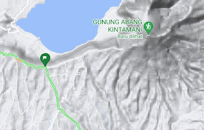
The green Hike Logo in the right side of that picture are mount Abang top. So there is a village below mount Abang and Bature Lake as a view. The green flag are registration spot, if you want to hike mount Abang, ride to the green flag first, do registration, ride again to parking area and start hike to Green Hike Logo in the right. Let me share you the registration spot by click this link below:
REGISTRATION SPOT MOUNT ABANG -- CLICK HERE!!
After do a registration to the officer, follow the road and sign to the second gate, here you need to pay for parking venicles. They will ask you about how many days you would spend on mount Abang, so they will charge you as long as day you spend. After paying parking fee, just follow the road to parking area. Better find a cool place for parking you venicle. After that follow the track, this is only single track through the hill with Batur lake View on your left side.
How Much does it Cost to Hike to Mt. Abang?
This part let me talk about money. This depend on administration and many others. Hike on Mount Abang actually dont need much cost of it. The first you need to pay is in registration spot of mount Abang. Located in three-way Junction where i share above, in my case we have about 7 people and from all of us just need to pay Rp. 30.000,00. This is actually cheap but they dont give us any tickets or insurance. I know for many traveler cheaper is better, but when you start to think about safety, more price for safety is better than nothing at all.
Second part is parking fee, for 2 days parking in the starting track of Mount Batur they just ask Rp.10.000,00. For motorcycle so it can be said that each day for a motorcycle cost Rp. 5.000,00. I have already ask to the officer if you go there by car. Each day you will charge by Rp.10.000,00. There is a gate that guard for 24 hours to the starting point and parking area, so dont worry about the security.
If i calculated all cost from where i live in Buleleng, because i stay over night in Mount Abang, so i buy logistics and snacks. This is the detail:
Logistic and Snack Rp. 70.000,00
Entrance Mount Abang Fee Rp. 5.000,00
Parking Fee Rp. 10.000,00
Motorcycle Fuel From and to Buleleng Rp. 50.000,00
Lunch Mujair Nyat Nyat Rp. 30.000,00
So for this all journey, i just need to pay Rp. 165.000,00. You can choose by your self between car or motorcycle, between stay for a night or just do a trail run hike, etc. So the cost actually depends on your activity.
What Can You do at Mount Abang?
Many people do a short hike or further many people do trail run. Short hike meaning you can finish in the top less than 1 day hike. So not much logistic actually needed if we want to do a short hike. But latterly there is sport i know called trail run, people run in a steep track for hiking and change to be trail run. Because the way is running, so it need much more stamina but less time and less logistic.
Short hike track like mount Abang do not provide many view choice. For me, it have a different feeling beside short hike and long hike. Long hike give us different view, different feeling each part of track, tjrough the jungle, through tha summit, lake, and many others. But short track much more simple than that. In Mount Abang it self, hike, built tent, cooking, but same view of batur lake and mount batur. So there is not much you can do here. Beside of that, the peak of mount Abang not cool at all for me.
After said all of that paragraph above, there was a stunning moment in this mount Abang hiking Area. I built my tent in a post that have a small hindu's temple before summit. We hike at afternoon so we arrived at that post about 17.00 Central Indonesian Time. Anyway, Central Indonesian Time is GMT+8 based on Global time. The sunset is at about 18.15 Central Indonesian Time. This is good moment and i have a couple time to set up my tripod and Camera. The stunning moment here is the sunset view.
You already know based on my explanation above that view from Mount Abang are Batur Lake and Batur Mountain. And it is on the west of Mount Abang, when we talk about west, there will always a sunset view. This is amazing view, Sun light at sunset time here blocked by mount abang, so it make an amazing photo. This is on of my best photo in here using my Canon EOS 800D Camera.
 |
| Mount Batur and Batur Lake Sunset (Captured By Yu, Canon EOS 800D, EF-S 10-22 mm f/3.5 - 4.5 USM, Shoot at ISO 100, 10 mm, f/5.0, 1/1600 second, LR Classic) |
That was a very good moment in the afternoon here. Enjoying sunset in front of my tent, talking about many stories and experience with new friends, that was quite amazing holiday from me altough the first plan was Mount Agung. Another spot is milkway, but i cant find one because that day was full moon day. Besides of that, the position of milkway here is in the south area of caldera Batur. I try use photo pills app to check the milkway position is behind the trees, so its pretty hard to get a good photograph of milkway here.
I stay over night in my tent, I have a pretty cool photograph too when the full moon light rays on fog. The light was amazing and shine the small temple there. Not much view in the night because in front of us only lake and mountain and small villages. I think fog and cloud start to block that view.
 |
| Mount Abang Full Moon Ray (Captured by Yu, Canon EOS 800D, EF-S 10-22 mm f/3.5 - 4.5 USM, Shoot at ISO 1600, 13 mm, f/4.0, 10 second, LR Classic) |
When there was a sunset in the west, it always there was a sunrise in the east. But let me say it clearly that if you wait sunset here, all you can got only disappointment. The sunrise blocked by trees, if you cut all the trees in the east side, it was still blocked by mount Agung. So terrible. Anyway, some people start to do a summit attack in the morning. But for me? No, there was nothing i can enjoy there. So what can i do in the morning were sit in the tent, cooking, and start a good music. Enjoy the dancing cloud above the lake.

What is the conclusion about Mount Abang Hike Activity?
I know this is the part that i need to honest about my feeling. How much i enjoy? Honestly i enjoy the photography moment and talking with new friends moment. But for the track? Absolutely no, this is too short for a hike, and too many dust everywhere. The sunset amazing but the sunrise was bad. Milkway position cover by tree and the tent area was very small. If you want to stay here for a few days, there is water here except you need to jump about 500 m to the cliff. For me, this is just a revenge about my day, thrown away from Agung Mountain. This is not a mountain adventure that i want to enjoy.
If you have a plan to jungle track or trail run, maybe this is a fit place. Only need a few hours and you can go back with a fit condition. Photograph moment was only at sunset. Let me give this place 6 from 10 stars.


Komentar
Posting Komentar