How Caldera of Mount Batur Form, Kintamani, Bangli, Bali Island
This is my pre stories about Mount Batur in Bali Island traveling Weekly. Everybody loves being in Bali and other ways Bali Island provide various amazing place to holidays. i've been in Bali about 1.5 years from the beginning of Corona Virus Disease 19 attack Bali 'til now but there are many place in Bali that I have not visited. But many of them I have visited several times because it was near to my home in Bali. one of them is Mount Batur.
 |
| Mount Batur from Mount Abang (Take With Canon EOS 800D, EF-S 10 - 22 mm f/3.5 - 4.5 USM, Shoot at ISO 100, 15 mm, f/4.5, 1/2000 Second, |
"The Beginning of Mount Batur"
Many Text tell a story about the beginning of mount Batur but little hard to understanding because it contain many scientific word that common people hard to understand. many text tell about the rock, how to calculate ages of rock by its C, and many others. so here I will tell you simply about the beginning of Mount Batur with a Common Language. let me start it with several word like Caldera, Eruption, and Collapse. this 3 words are process that built mount Batur nowdays.
Where is the location of mount Batur? i give this link below to direct to google map for location of mount Batur.
LOCATION OF MOUNT BATUR ---> Klik Link to Google Map
all of this information refers to many paper and most of them in Indonesian Language like MAGS and many text in internet. but the first of all is in Mount Abang trekking starting point. Mount Abang is part of Batur Caldera Now days and become the highest altitude in Batur Area. in all if Bali, Mount Abang Become 3rd Highest peak in Bali Island. this is part of Ancient Batur Collapse. or you can read in the Batur Geopark Museum. anyway lets begin to the simple explanation.
1. Ancient Batur Mountain (About 29300 Years Ago)
Ancient Batur was a stratovolcano or cone shapes mountain. it was very high and higher than mount Agung the number 1 highest peak in Bali right now. anyway Mount Agung peak at altitude about +3031 m Above Sea Level. So it was very high volcano and maybe become the number 1 peak of Ancient Bali Island, So where is Mount Abang now days? Mount Abang just part of the Ancient Mount Batur (Picture Below)
 |
| Picture 1. Ancient Batur Mount |
then, about 29300 Years Ago, Ancient Batur Mount Erupt and the peak of this mountain Collapse, make a big Caldera now days and it called the Caldera 1. The caldera is a pan-shaped muntain peak formed by a large eruption that occurred. the eruption was explosive and destroyed the shape of the top of the mountain, so that the walls collapsed and formed a pan-shaped. this is the result of the eruption about 29300 years ago (Picture 2)
 |
| Picture 2. Ancient Batur Mount after Eruption |
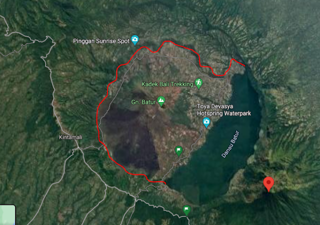
Here the interesting thing, I try open google map of mount batur and change it to satellite views, you can actually see the form of Caldera 1. it was very big and form about 13.8 x 10 km.
 |
| Caldera 1 Form in About 29300 Years Ago |
You can see the red spot that I point using google map, that is mount Abang. so mount Abang nowdays that become the highest number 3 of Bali Island Peak only a small part of the great ancient Batur High. the red line that form circle is Caldera 1, form after the ancient Batur Erupt in About 29300 Years Ago.
2. Second Eruption and Collapse (About 20150 years Ago)
the time flies after the big collapse, about 20150 years ago, there is a chance that small little young batur mountain form in the middle of caldera 1 (like now days that we called this mountain mount batur) the young small little ancient Batur form but in about 20150 years ago, it suddenly erupt again. (Picture 3)
 |
| Picture 3. Ancient Batur Mountain about 20150 Years Ago |
The eruption so big and suddenly make a secondary collapse of this mountain. the secondary collapse perform the second caldera that we called caldera 2 (Picture 4.)
 |
| Picture 4. Ancient Batur Mountain After Erupt and Collapse about 20150 Years Ago |
it was similar like the first process because it form the second caldera. let me show you in google map satellite view below.
 |
| Caldera II form in About 20150 Years Ago |
Red Lines of that picture perform the second caldera that form after collapse and erupt in about 20150 years ago. it was not form a circle-shaped because some of that already fill with water of Batur Lake now days. anyway, maybe if we can dry or mapping the bottom of batur lake, there will be continue of red line there.
add water from raining and many other resource, the caldera of mount batur will fill with water and form Batur Lake. i know it was sound crazy, when i read it for the first time in Mount Abang trekking Starting point, i feel crazy too. many places in mount Batur that can be a great adventure. you can see the great history by learning and see it by yourself, the power of mother nature.
All of those picture was created by my self using paint program depend on what I have read in Batur Geopark Museum. this is just a small part of anything that you can do in Batur Geopark area. Hiking, Camping, Swimming on a Cold Water, Swimming on a Hot water, eat Mujair Nyat - Nyat that a food from this area and amazingly become my favorite food in Bali, playing motocross riding in Black lava of mount batur, and many others. I hope you can visited this place, almost 2 years Covid 19 attack Indonesia and Balinesse people who lived from tourist attraction suffer from this pandemic. when you have time to stay in Bali, dont forget to visit this amazing place. have a nice day.
References for PDF of GeoMags, link Below) in Indonesian Language


Komentar
Posting Komentar